Hi Friends,
I often play around with this database and sometimes also use this in my assignments and demos. The MONDIAL database has been compiled from geographical Web data sources like CIA world factbook, Global Statistics, etc and is available in several formats. The SQL one is here;
After you download, extract, and create the database. Here are some interesting queries that we can run and get spatial output:
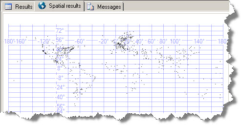
In the above query, the city table has Longitue and Latitude column. I have used the static Point method of Geography data type to plot the longitude and latitude – the spatial tab shows spatial results in SQL Server Management Studio. 4326 is the default spatial reference ID.
Download the database and explore it – I am sure you will find the data very interesting to play around with !
hi
that’s very good and useful!
but where can i find more sample queries in this database?